
Rogers Pass Backcountry Conditions Report March 13, 2023
 Rogers Pass Backcountry Conditions Report March 13, 2023
Current Snowpack Synopsis
The green brick, it happened! A week of all-time riding conditions with relatively clear skies and cool temps made room for some adventurous descents. Lot’s of folks were stepping out and riding some big lines; there was probably a fair bit of pent-up enthusiasm after a winter of trepidation around bigger terrain. It felt good be able to burn the jets a bit.
That said, the November facets aren’t gone yet. There was evidence of natural avalanches stepping down to them in bigger terrain, such as Ross Peak and a cornice fall southeast of Parsons Peak. They also have continued to produce large destructive avalanches in the areas surrounding Rogers Pass with large loads and explosive inputs. With this pulse of snow, wind and the ensuing warming, expect to see them wake up and produce more large destructive avalanches.
Mt Fidelity’s weather station at 1905m is now reading 264cm for a height of snow. According to the Mt Fidelity weather station, 41cm of storm snow has fallen with 45cm of settlement in the height of snow in the past week. Since early Sunday morning, 33cm of snow have fallen with rising temperatures and moderate south-southeasterly flow. Currently, temperatures at 2000m are hovering around -2 degrees Celsius.
Coverage on the glaciers ranges from less than a meter in typically thin areas to over three meters in more sheltered areas. Crevasses are looking relatively well bridged, however the coverage resembles a lower snowpack year, as opposed to what things have looked like in the past few seasons. There are still some gaping holes and vigilance is required while travelling in glaciated terrain.
After five weeks of consistent snowfall, we’ve just had a more than a week of relatively clear skies. During that time there was significant surface faceting, surface hoar growth (up to 8mm) and crust development on solar aspects. In some areas, surface hoar overlies the melt freeze crust.
The mid-pack is gaining strength and rounding.
However the November facets are still prominent at the base of the snowpack. The facets are showing signs of rounding, but there is still a considerable step in resistance between them and the overlying snow. The November facets are more pronounced in shallow rocky areas.

What’s been riding well
Over the past week there has been exceptional alpine riding paired with good stability. Lot’s of big lines were ridden and backcountry travellers took advantage of the fantastic travel conditions.
With the arrival of clear skies, sheltered alpine features and sheltered areas at tree line and below have been the place to be. In exposed areas, there was significant wind effect from variable winds. Steep solar aspects below 2300m ESE-WSW had a melt freeze crust up to 2cm thick.
The recent melt freeze crust on steep solar aspects is significant; look to ride on the shady sides of trees when travelling in BTL solar areas.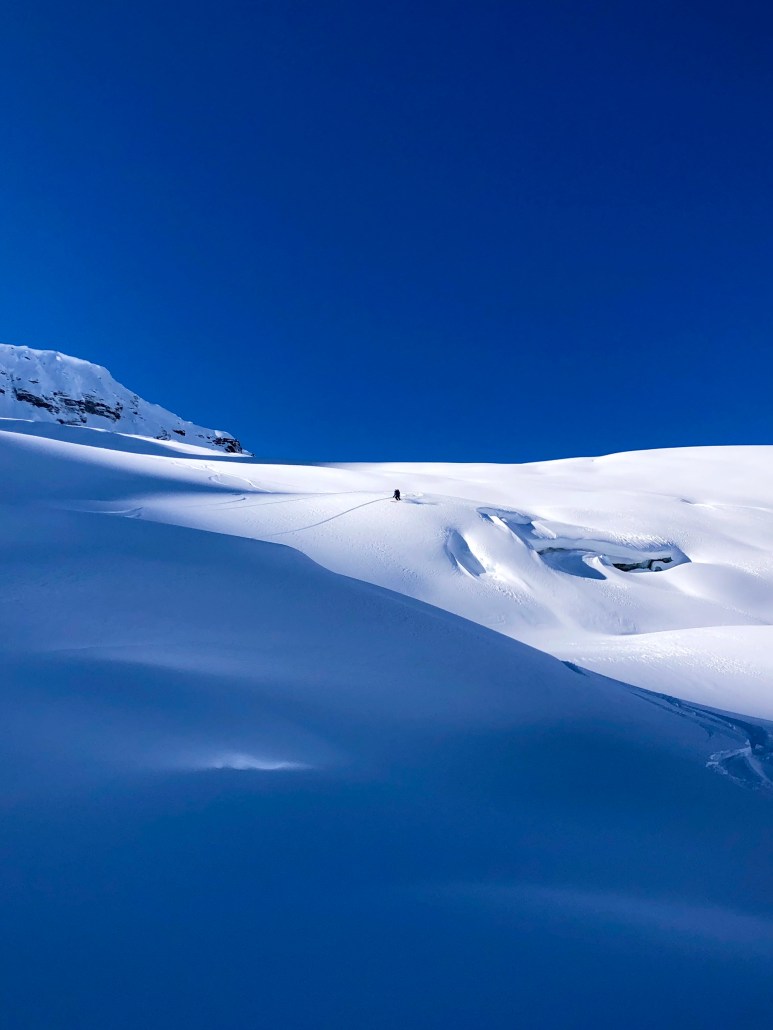
Recent Avalanche Activity
Currently, the avalanche hazard in Rogers Pass is rated at high and there is probably a natural avalanche cycle that is happening while this report is being written.
Over the past week, there were numerous natural cornice failures in the region.
Minimize your exposure to cornices, they are big and have faceted roots; the moderate winds, warm temperatures and new snow will have added mass to cornices. They will be sensitive, particularly the solar input that will follow this storm cycle. Natural cornice failures have been observed in Rogers Pass and surrounding areas.
Recent moderate to strong southwest through southeast winds will have created storm slabs in immediate lee features and exposed areas in the alpine and treeline. Watch out for reactive storm slabs in sheltered tree line and below treeline features where the new snow overlies surface hoar and melt freeze crusts.

Incoming weather and avalanche forecast
A shift towards spring. As this system passes, a ridge will develop bringing cooling temps and clearer skies. Look for spring time convective activity as the valley bottoms warm up.
Avalanche Canada Mountain Weather Forecast
Avalanche Canada Public Avalanche Forecast
Snowpack Concerns
Cornices: Minimize your exposure to cornices, they are big and have faceted roots. Cornices have grown significantly in recent weeks and there have been numerous natural cornice failures that have resulted in avalanches up to size 3 in, or around Rogers Pass. Give them respect and a wide birth when you are travelling under them. Be cautious of solar input.
Storm slabs: Recent moderate to strong southerly winds have created storm slabs in exposed areas in alpine, tree line and below tree line features. Warming temperatures and 30+cm of new storm snow will have produced a natural avalanche cycle today.
Dry/ Wet Loose: Watch out for sluffing in terrain over 35 degrees. The sun packs a punch this time of year, steep solar aspects will become active when the sun comes out.
Deep Persistent Slabs: The November facets are still very much a concern across the backcountry ski / snowboard industry in the Columbia Mountains. This past week exhibited continued natural avalanche activity failing on the November facets. They will need a bit of time to adjust to the new load that has been applied to them.
Be aware of overhead hazard.
The November facets are more pronounced in shallow, rocky features. Professionals are still maintaining a conservative mindset with this low probability/ high consequence avalanche problem.
Access Concerns
Disclaimer
Backcountry skiing and splitboarding are inherently dangerous activities. Decisions made about terrain in which you may choose to travel should be based on real time data you’ve collected firsthand, not on this report. Conditions in the mountains change rapidly, please be aware that things will probably have changed since this report was written.
Leave a Reply
Want to join the discussion?Feel free to contribute!